There’s a Map for That!
One of the things I’ve always loved about fantasy novels, is when they come with a map. It’s not just a guide to where the characters travel, it’s an invitation to step into another world.
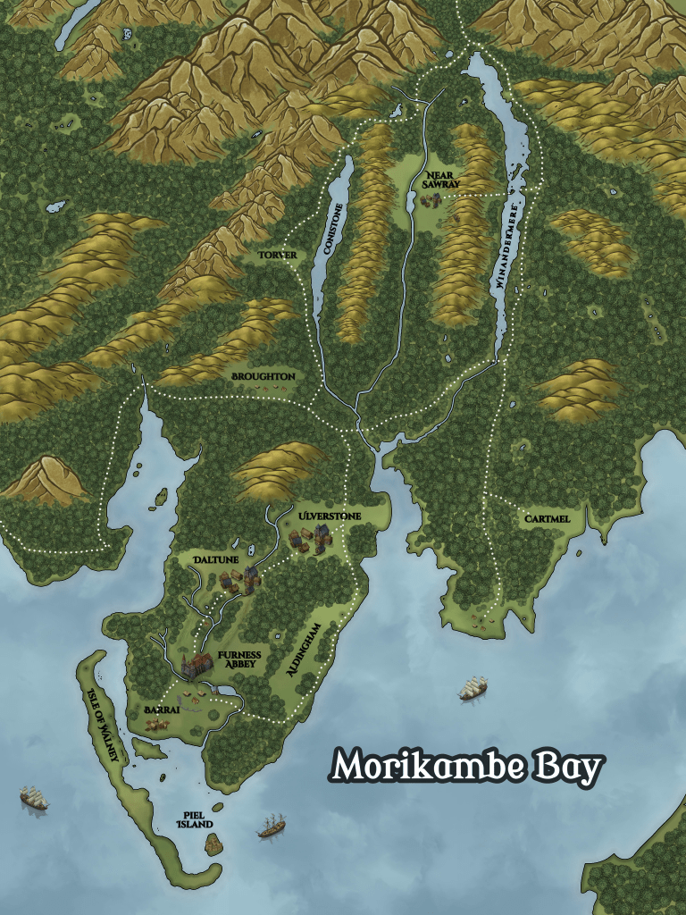
I’m excited to say that The Mereland Chronicles: The Crier includes its very own map, printed in black and white (based on the colour map below), to help you trace the journey as the story unfolds.
A Peninsula Both Real and Imagined
The map is based on the Furness Peninsula in Cumbria, a landscape that has inspired me for years. If you know the Lake District, you’ll spot the familiar features; Windermere, Coniston, the fells, Barrow in Furness, Ulverston, Dalton, etc – though I’ve added a slight fictional twist and used older place names. This blending of real geography with a touch of invention helps root the story in history, while still allowing me to shape it into something unique.
Old and New Place Names
One of the details I wanted to capture in the map was how place names evolve over time. Some of the locations in Mereland use their older, historic forms to give the setting a stronger sense of depth and age:
- Ulverston was once known as Ulverstone.
- Dalton-in-Furness appears as Daltune.
- Barrow-in-Furness, the industrial town at the tip of the peninsula, has roots in the older form Barrai, which originated as a grange/farm.
These older names tie Mereland to the history of Furness and remind us how landscapes and language shift with time.
Forests Then and Now
You’ll notice on the map that the forests of old covered most of the peninsula. In fact, it wasn’t just Furness, much of England was once dense woodland. It’s only through centuries of human activity that the fells and valleys have been stripped bare. That loss of the natural world is a theme that runs throughout The Mereland Chronicles, and one I’ll continue to explore as the series unfolds. I’ll admit that in the time period this novel is set, the reforestation was probably more advanced – but you get the idea.
If you’re passionate about the Lake District, rewilding, or broader environmental concerns, you’ll find echoes of those issues woven into the series.
How the Map Was Made
I created the map using Inkarnate, a brilliant tool designed for making fantasy maps. It allowed me to bring together the contours of the Furness peninsula with the textures of forests, fells, and settlements in a way that feels authentic yet atmospheric.
Why Include a Map?
If I’m honest, it was largely for personal interest. I’ve always been fascinated by maps. Sad, I know! But they give stories an added depth, and I hope readers will enjoy flipping back to it while following the characters journey through Mereland.
Keep an Eye Out…
This isn’t the only reveal I’ve got planned. There’s a big announcement coming in the next two weeks, so keep an eye on this website, my blog, and my social media:
- Instagram: @p.j.scribbansauthor
- Twitter/X: @PJScribbansAuth
- Facebook: P.J. Scribbans Author
Exciting times ahead. The map is just the beginning.
– Scrib
